The stratosphere is the portion of the atmosphere above the troposphere between about 12km and 48km, and 250mb and 1.2mb. In the lower stratosphere the temperature is at a minimum at the equator and has maxima at the summer pole and at about 45 latitude in the winter hemisphere. From thermal wind considerations the rapid decrease of temperature polward of 45 in winter requires a zonal vortex with strong westerly shear with height.
In the northern hemisphere, every other year or so this normal winter pattern of a cold polar stratosphere with a westerly vortex is interupted in a spectacular manner in midwinter. Within the space of a few days the polar vortex becomes highly distorted and breaks down with an accompanying large-scale warming of the polar stratosphere, which can quickly reverse the meridional temperature gradient and (through thermal wind balance) create a circumpolar easterly current. Warmings of 40K in a few days have occured at the 50hPa level.
A "major warming" in which the mean zonal flow reverses at least as low as the 30-hPa level seems to occur only about once every couple of years. If the major warming occurs sufficiently late in the winter, the westerly polar vortex may not be restored at all before the normal seasonal circulation reversal.
In summary, if the magnitude of a stratospheric warming event is large enough, the warming can once in a great while propogate down to the tropopause. The reason for the infrequency is that the warming is occuring at a level where the density of the air is just 2% of the density of the air at the tropopause, and about .2% of the density of the air at the surface of the earth, and since temperature is directly proportional to density, significant changes in temperature can be lost as propogation downward occurs. When it does happen however, warming at the pole results in a displacement of arctic air to the south, and has a direct correlation to a negative NAO and AO.
-
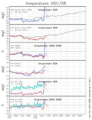
This current event, and the days leading up to it, are unprecedented, and it remains to be seen what happens next. Here is what I can tell you though. The overall behavior of the stratopshere has been anything but normal during the past 72-96 hours.
We were close to record breaking low temperature at around 198K, at 10 mb, on 1/20. The real change didn't start to occur until about 48 hours later, on the 22nd. The rise in temperature between 1/21-1/23 was monumental, and it's unprecedented from this starting point.

From space weather specialist Jim Hughes 1/24 2pm:
Reliable historical data only shows about a 13 degree maximum rise within 48 hours, [from 200K]. But we have seen a 38 degree temperature rise occur. So this is almost three times the prior record, and we are still seeing some more extensive warming going on today.
The ECMWF is forecasting it to reach close to 258K today. So this would be about a 60 degree temperature rise within 72 hours. The sharpest rise I can find from any starting point, for a three day period, is about 40 degrees.
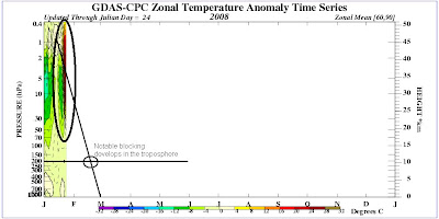
The normal time span for stratospheric warming to propogate to the surface is 4 weeks, with notable blocking developing by the time it reaches the tropopause around week 3.

In addition, the ECMWF went to an extreme in the long term forecast with respect to blocking: The Jan 28-29 Upper Midwest blizzard continues strengthening as the storm moves NE through Canada, pushing a very powerful ridge out ahead of it. Northern Maine is +5 at 850mb by the 30th. The storm enforced ridge moves across the Bering Straight / Greenland around the 30-31. At this time, a 582dm block is moving north from a position just east of New Foundland. Where this model becomes different from others is that a powerful ridge then sustains and strengthens over Greenland through February 3rd. Not a transient 24-36 hours. If this model verified, daily NAO values would probably approach the -3 to -4 range, and blocking would occur long enough to send cold down from Canada. Whether the cold is centered of the Midwest or East is entirely based on the Pacific. Last night's Euro says Midwest.
My long term thoughts havent changed very much, more so have been scrunched into a smaller time period. We will still likely see above normal temperatures through the beginning of February. Then, as the stratospheric wave reaches the troposphere, we see blocking develop and much colder air flow into the region. Still anticipating a major snow event for the beginning of March as well.
What to expect at the surface:
1) Temperatures 1 to 3 degrees above normal between now and February 7.
2) Severe weather potential followed by a rapid cool down around the 15th to 17th.
3) Arctic cold spread across the mid west and Great Lakes region, eastern edge over New England starting by the 20th. Temperatures over 4 degrees below normal through March 10th.
4) A major snow event possible for the eastern third of the country sometime between Feb 27 and March 9.
No comments:
Post a Comment