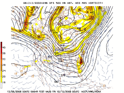
12 hours ago (00z)

The 06z is much slower than the 00z and tilts the storm negatively early, which allows it to turn northward faster. This brings warm air northward and makes it a rain event for many on the east coast.
6 hours ago (6z)

The 12z has an even SLOWER timing than the 06z (as in not STARTING until Friday afternoon!) and is clusted with the NAM and UKMET which have the same slower timing.
Latest (12z)

It's overall solution is actually great for the east coast, but the main problem is really in its inconsistency. Plus, the pattern is about to change to a west coast trough + east coast ridge set up. If the storm is pushed back any later, we run into the problem of ridging beginning to build and a warmer solution with an inland runner.
The 12z ECMWF is notably further northwest than its 00z run. However there is something to be said for this run being suspect. The Euro has a slight warm bias, especially in the mid levels. The 12z run still works out decently for interior New England. The Euro is considerably faster than the GFS/NAM/UKMET and shares similar timing to the GEM.
At this point, I am swayed to the Euro, with its greater consistency. Timing wise, it looks like a Friday morning storm, however there is still a lot of spread in the model forecasts.
Again, one thing to be noted is that no model has showed a totally out to sea or inland track yet. As much as they have varied considerably in timing and run to run consistency, the track forecasts have been clustered decently which is a good indication for a New England winter storm.
No comments:
Post a Comment