Model guidance has trended slightly east with the coastal low Sunday Night - Monday, so main accumulations from that storm will be focused along I-95 where a couple extra inches may be tacked on the Sunday clipper totals. Meanwhile, there has been a general trend toward a wetter storm tomorrow, with water equivalent around .4". This will support widespread 4" to 7" amounts over interior New England (north of I90 and west of I95), with lesser amounts toward the coast as boundary layer temperatures make for some ptype issues.
The coastal low will add light accumulations to Hillsborough and northern Worcester county, where the axis of heaviest totals is likely.
Further north, moderate to heavy snow will impact southern Maine through Monday, with accumulations around a foot likely.
Snowfall through Monday morningKeene: 4" to 7"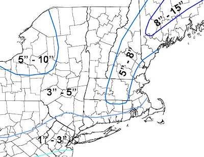

No comments:
Post a Comment