Tuesday - Wednesday (2/26 - 2/27):
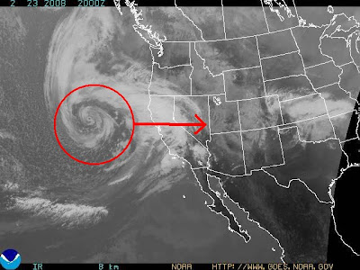
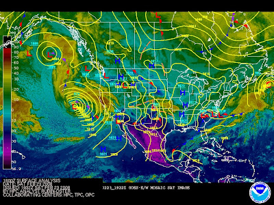
Deep low pressure currently located in the eastern Pacific Ocean continues to show an impressive satellite display. Forecast model initialization suggests that warm seclusion occurring, where the cold front overruns the warm front with the warm front wrapping around the low cutting off warmer temperatures underneath the low center. This storm will weaken as it approaches the west coast, and becomes sheared.
The low will move ashore northern California tomorrow afternoon. The leading short wave trough enters northern Utah. S/W then moves west into the central plains and strengthens, reaching sub 1000mb before entering Missouri. Missouri is where most model forecasts take the S/W to before the forecasts diverge more significantly.
The 18z exp NAM takes the low through central Missouri, through southern PA, and along I95 into the Gulf of Maine, with min pressure at that point (06z Wed) of 984. 850mb 0c isotherm cuts through, but never north of the area. Wide swath of 1+" water equivalent, with 1.4" in Keene.
The 12z op GFS take the low through northern Missouri, northern PA, and over western New England at 06z Wed with a pressure of 988. 850mb 0c isotherm lifts north of the area at that point, but only after the bulk of precipitation moves through. The GFS is less robust than the NAM with water equivalent, with most areas under an inch, and .9" in Keene. There has been an significant overall south and east trend in the past 24 hours.
Both the NOGAPS and UKMET forecast models are eastern outliers, taking the low through southern Missouri, south of PA, and off the Delmarva peninsula before tracking it northeast over the benchmark. The Canadian REG and GGEM are also further south compared to the NAM and GFS.
Main concern at this point for the storm is ptype. Consensus is still for the low track to encourage enough warming to raise temperatures above freezing both at the surface and mid levels. One factor not in the mix with this storm unlike the past two storms is antecedent cold. The next 72 hours will hold above normal temperatures in the east as high pressure moves offshore tomorrow. There will be no strong high to our north, only a weak pressure maxima. This will limit reinforcement of cold, allowing most of the cold to be scoured out in the same timing as the mid levels. This factor will limit icing potential, leaving the storm to be a mainly snow or rain event. The next factor in determining the low track and resulting air mass and ptype will be the polar vortex. Forecast models indicate the polar vortex inching southeast to a position at 72hrs at 60N/60W (west of Greenland). With a +NAO in place, and a very positive AO, the PV will hold as a negative height block, holding a long wave along 80W to 85W, suggesting S/W amplification at this point. A stronger and further south PV would assist in deflecting the S/W to the south. With this in mind, this is definitely not a situation in which the low cuts north to the Great Lakes. In addition, +PNA ridging should assist in keeping heights lower downstream in the SE US.
A lack of true blocking will mean once again a short duration event (<24hrs). Potential exists for a signficant front end dump of snow before WAA changes precipitation briefly to freezing rain or rain, and then back to snow behind the departing storm. Timing is becoming even more important now that we are in late February with stronger solar heating. A nighttime event (likely Monday Night or Tuesday Night) would increase favorability in keeping ptype primarily snow. First forecasts will remain conservative due to a lack of real continuity in the models.
Snow accumulation forecast: 3" - 6"
---
Below normal airmass moves into place behind the departing low. Remember, now in late February, below normal temperatures include 30 to 35F.
Another storm is possible on Saturday. Clipper system dives southeast on Friday. Leading short wave swings across West Virginia. Frontogenesis south of the region may enhance moisture for a time. The ECMWF has suggested possible coastal development along the short wave axis. The GFS has alluded to this in previous runs. This scenario would mean a more moderate snow event for the region. At this point however, will maintain light snow accumulation forecast.
Snowfall estimate: 1" - 3"
---
Sunday - Wednesday (3/2 - 3/5):
Strong MJO signal developing in the next few days will allow systems that normally die off over the Pacific to maintain intensity. This will mean a very active pattern for the CONUS as we enter the month of March. EPO could strengthen for a time, resulting in a -PNA trough downstream and a brief warm up for the region for the first few days of March. Next PAC system on board will increase heights over the eastern third of the nation.
The GFS 12z and 18z runs have suggested a very intense storm, with an incredible temperature gradient along the trough axis, and a coastal low with snowfall rates that would make storms like 1996, 1993, and 1888 look like dustings.
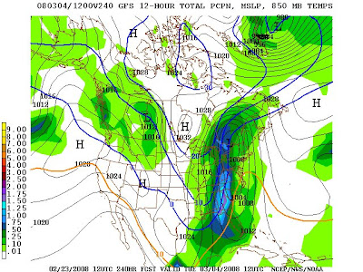
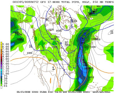

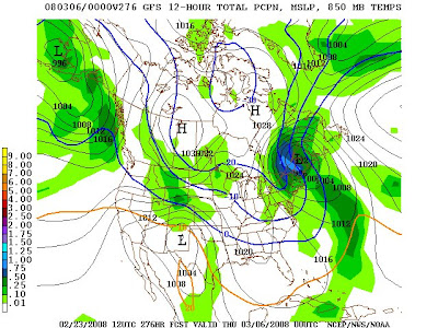
The enormity of the GFS forecast is all about details, but obviously those will change over the next 10 days. The real significance is the signal for a highly volatile pattern for the first two weeks of March.
No comments:
Post a Comment