The following are storm reports from Cheshire County yesterday evening:
4308 7243 TREES DOWN ON ROUTE 123.
4308 7210 TREES DOWN ON ROUTE 123 AND ROUTE 9 IN SOUTH STODDARD.
4287 7228 TREES DOWN ON SWANZEY LAKE ROAD.
4297 7245 TREES DOWN.
On top of reports of wind damage across the county, heavy rains have caused some small stream flooding. At KEEN, 1.59" of rain has fallen in the last 24 hours. More is to come, possibly today and/or tomorrow, but in larger quantities Wednesday and Thursday.
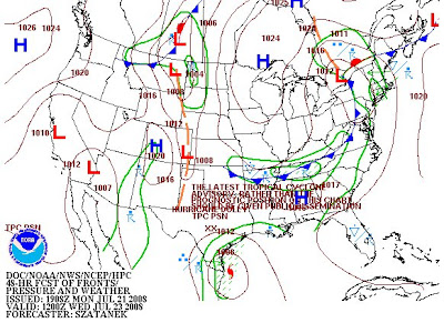
The cause of all the thunderstorms and the wet weather is a stationary frontal boundary that has been vascillating across the region. At this time, the front is located to our south, in northern MA. To the south of the boundary, a very warm airmass remains intact with KHFD reporting 89 at the moment, while KEEN sits at 75.


Low pressure on the back end of the frontal boundary is currently over the Great Lakes region and will be moving slowly eastward, while a plume of moisture gets pulled northward out ahead of it on Wednesday raising PWATs (Precipitable Water) levels up to 2.0". Combined with a strong high pressure dam to the east forcing strong jet dynamics over the region, we have the makings for training thunderstorms and copious rainfall. Current model forecast estimates range from 1 to 3 inches.


Having this on top of what has already fallen in SW NH will likely aggrevate rivers and streams to the point of some rising over their banks. This situation will need to be monitored closely. Aside from the potential for torrential rains, severe thunderstorms look unlikely at this time considering constant a thick cloud deck, however CAPE up to 1000J/kg could assist in storms with strong winds.
www.KeeneWeather.com forecast
for 00z Tuesday through 12z Friday (60hrs):
Wednesday: Rain will enter the region from SW to NE, reaching KEEN between 10am and noon. There may be a break between 6pm and 8pm before another round of showers and thunderstorms moves in. A third and fourth round of thunderstorms will move through Thursday morning. The rain may be done by 3pm Thursday, with only scattered showers following Thursday Night into Friday. Dew points will range between 66 and 73 through the period, with high temperatures 82 to 84 both days and lows 64, 70, and 61 for TUE N, WED N, and THU N respectively. Total period rainfal: 2.5" to 3".
No comments:
Post a Comment