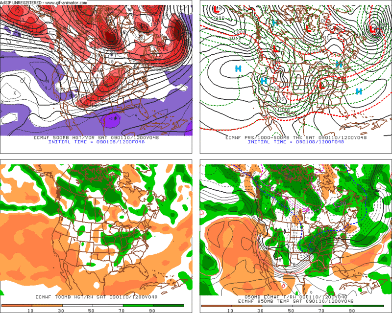
Model guidance continues to display a clipper system deepening while moving south of New England. The ECMWF, UKMET, GGEM, and NAM have been consistent with this solution and a significant snowfall for all of SNE. However, the GFS has been on the south side of guidance, with the clipper staying fairly flat and progressive resulting in no building ridge ahead of the storm to push it north.
The main difference is that the GFS is much quicker with northern stream energy through Friday Night, with the vorticity maximum over Illinois by 12z Saturday and southern stream energy back in New Mexico with a very positive tilt. The 12z ECMWF by contrast has the northern vorticity max over southern Wisconsin with a much less severe positive tilt to the shortwave. This leads to the two pieces of energy phasing quicker on the ECMWF and able to amplify, while the southern stream energy is still trying to catch up to the northern energy on the GFS.
As a consequence of this, the GFS is also much quicker in moving snow in and out of the region. At the surface, the GFS brings low pressure through Kentucky, into Virginia by Saturday evening, and south of the benchmark just after midnight, with snow wrapping up in SNE. The ECMWF has low pressure moving through Ohio and has it over interior SE NY by Sunday morning with heavy snow falling in the region.
The NAM is sort of compromise between the ECMWF and GFS. It has surface low pressure passing through Maryland and south of LI, inside the benchmark, by Sunday morning. Timing is close on the ECMWF and NAM, and so that consensus should provide a good indication of the GFS being off. So for a timeline, snow should begin around midnight Sunday, falling heavy at times between 4am and 9am, before tapering off early Sunday afternoon. The extent of the rate and duration of snowfall will depend on the exact track of the storm.
However, the NAM is also still notably south of the Euro track. While it is in the middle of the guidance and a good representational average, I don't feel comfortable giving credence to a model that has a history of perrforming horribly not too far from it's initiation. So at this point, I'm just taking in what I can from each model and waiting for a consensus or a trend at least. The ECWMF has had good run to run consistency, so I tend to lean in that direction at this time.
Verbatim, the NAM hits interior CT, RI, and SE MA the hardest. The ECMWF slams interior SNE and CNE (Keene), while the GFS gives the most snow to NYC and the New England south coast.
This storm will aquire a Gulf connection as it tracks across the Ohio Valley, and between that enhancement of moisture and excellent snow growth, I think there will likely be a stripe of 6" - 12" somewhere in SNE. Precipitation type should not be a problem away from the south coast and cape. Even the northern most solutions keep precipitation in the form of snow across N CT, and N RI points north.
At this stage in the game, I am thinking 3" to 7" for here in Keene, although a trend north could bump that up notably, and a trend further south would chop off a few inches from the top of the range.
No comments:
Post a Comment