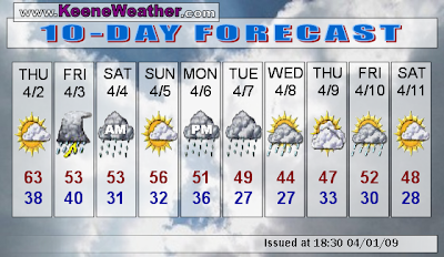
The weather in New England over the next 60 hours will come close to replicating this past weekend. Tomorrow will start off with some clouds as low level moisture hangs around for a bit, but it should clear out by the afternoon allowing mostly sunny skies. Eastern New England will have to contend with the low clouds through most of the day. 850mb temperatures will start out around 2.5C, but should increase to around 5C in the afternoon as warm air advection moves in ahead of the next system. This combined with solar heating will push highs into the 60's.
Strong low pressure will move into the Ohio Valley Thursday night with a triple point located over Virginia. Clouds will be on the increase as moisture advects northward. Showers will overspread the region from south to north Friday morning. There will be a good bit of moisture with this system, with PWATs increasing to 1.1" Friday afternoon. In addition, total totals are expected to reach the high 40's to near 50. As the triple point passes over SNE Friday evening, we'll see some elevated convection with embedded thunderstorms definitely possible. Cyclonic flow with available moisture will maintain clouds and scattered showers through Saturday morning. This should lift northward with the system in the afternoon. All totaled, around .7 to .9" of rain is possible. Temperatures will stay on the cool side through Saturday with cloudcover.
At least one day of the weekend will still be nice. Anticyclonic ridging will build into the region, with at least partial drying of the atmosphere, allowing for partly to mostly sunny skies. 850mb temps will be on the increase as ridging crests Sunday evening. Highs should reach the upper 50's.
The storm train keeps rolling, and clouds will be on the increase Sunday night ahead of the next one. Showers should overspread the region on Monday with rain continuing through the night into Tuesday. Once again, cyclonic flow will keep a chance for showers Tuesday night into Wednesday. This storm will be carving out a deeper trough than any of the others, with medium range guidance dropping -10C at 850mb into the Great Lakes region. Expect at least a couple days of chilly weather following this storm with perhaps even a few snowflakes on the backside Wednesday. Beyond that point, the forecast becomes a bit more uncertain with respect to the strength and eastward progression of developing omega blocking over the nation.
No comments:
Post a Comment