Snow is winding down across Cheshire County. The banding that sat over the area most of this morning has rotated south and east. Low pressure will rapidly intensify southeast of the region, supporting strong convective bands of snow across eastern Massachusetts through the afternoon. Total accumulations in these areas will be between 5 and 10 inches. In Keene, excellent snow growth supported a period of large dendrites that accumulated up to 3" per hour at times with ratios around 20:1 !!! The storm was really only about 3 hours long, however accumulations of 6 to 8 inches have been reported across SW NH, and light snow through this afternoon could tack on another inch.
As this storm wraps up, it's time to look ahead. Behind this storm, much colder air will stream into the region. Highs tomorrow will not get out of the teens. With winds gusting to around 30mph, windchill values will tumble below zero tonight through tomorrow night.
The storm on the third that models were so well in agreement on for days disappeared. Flow will be more progressive, and the clipper that was to trigger coastal development will be the main show, with the secondary development well east of the area. Some light accumulations are not out of the question with the clipper.
A negative NAO should hold through the second week of January. This will support below normal temperatures through the period. After the 15th, ECMWF and GFS ensembles support the block breaking down. However, during this time, +PNA ridging will be built up in the west, with the EPO returning to neutral. So a trough may continue to hold tight over the east. I think a general cold east pattern will last through the 20th.
As for storm potential, January third has been eliminated, and that leaves the next 7 days dry for the most part. January 7th has been on the radar of many for some time, and that threat continues to be advertised on the GFS and ECWMF.
I'll have more this weekend, regarding how the rest of January looks to shape up, and some thoughts into February with a look at current tropical forcing and stratospheric tendencies.
Happy New Year everyone
Wednesday, December 31, 2008
Monday, December 29, 2008
Snowy week ahead
I haven't posted for a little while, as I've taken a break for at least the first part of Christmas break. And it was still justified as we experienced mainly rainy, warm weather during that period.
However, now we have moved back into winter. I did make one post on the main page outlining the potential storm for January 3rd. That threat still exists and I will talk about it later in this post.
First thing's first, just to bring everyone up to date, we have moved into a wintry pattern that will likely persist through the first couple weeks of January. As I predicted at the beginning of this month and in my winter outlook, we have moved into the negative phase of the NAO, and model guidence supports a -NAO block holding through the first half of January. The Pacific pattern is not quite as favorable. We have a strengthening +EPO that, without the -NAO, would have caused much of the east to blowtorch. But as it is, the -NAO comes to the rescue, and the eastern US, or at least the northeastern US, has many opportunities for snow ahead of us.
Three events are being monitored for this week:
1) Tonight - A strong shortwave will pass to our north. This wave will be starved for moisture. However with good dynamics, and a brief period of high RH and omega in the snow growth zone, there could be a couple heavy snow squalls that pass through the area later tonight (mainly after midnight). Total accumulation should be under an inch.
2) Wednesday - Another intense shortwave with associated surface low will cross Pennsylvania and exit just south of New England. All model guidence has been trending south with this storm. The GFS was the last to join the party and has really been failing lately for the record. As the low exits the coast, it will rapidly deepen into the 980's range as it passes just south of Cape Cod. This storm could produce some moderate w.e., and there is a general consensus for QPF of widespread .3" to .6" across northern CT, RI, MA, and southern NH and VT. In addition, omega of -15ub/s will be intersecting the snowgrowth zone with high RH, which will assist in some high snow to water ratios around 15:1 and locally higher. Axis of heaviest snowfall will likely lie near the Mass Pike, although there is definitely some adjusting to do. The GFS is still north of the rest of the guidence, with the NAM and Euro in agreement further south. This will be a widespread 3 to 6 inch snowfall for SNE and CNE, with likely a stripe of 6 to 9 somewhere in Massachusetts.
3) Friday N- Saturday - Low pressure moves into the Great Lakes with a secondary low developing and moving along the coast toward New England. Model guidence has been in agreement on the low rapidly intensifying to the 970's range near the region. However, there has been considerable discontinuity recently. Forecasts a few days ago were bringing the low inland, with rain for most of the region. Due to the developing block, these forecast tracks weren't counted on very much, and as expected, the models started shifting south and east. The Euro and GFS have showed big hits for interior New England in many runs. Verbatim, some of these runs support one to two feet of snow through Saturday. However, the GFS has been faltering about every other run with the intensity of the low, and recently the 12z ECMWF has a much weaker storm, with the latest UKMET and GFS following suit. At this point, just waiting for the 00z runs, as this sudden change doesnt make much sense. If it was just the Euro, then it would be disregarded as a fluke run, but the rest of the guidence coming in the same is a little worriesome. It is possible that the models digested some bad data. As I said, the 00z runs will clear it up ... hopefully.
Friday, December 26, 2008
LR Forecast so far on track
The beginning to January looks very much on track with respect to my forecast from earlier this month. The ECMWF and GFS operation and ensemble runs have been consistent in showing a moderate to strong negative NAO developing in the last few days of December and lasting at least through the first week of January.
I will post more on the January pattern later, as well as a look at February in a few days. For now, I want to focus on a specific day which currently insists on attention: Saturday, January 3, 2009.
Both the Euro and GFS have been indicating for numerous runs the potential for a Miller A/B hybrid affecting much of the east coast on the 3rd.
 The 12z 12/25 ECMWF showed a very strong Miller B sitting off the coast of New England at hour 216 (12z 1/3).
The 00z 12/26 GFS shows a storm more in tune with the hybrid type I mentioned, and the latest HPC long range D7 map as a blend of the Euro and GFS displays this as well. In addition, with the development of a more west based -NAO, the strong blocking is shown to hold this storm in place near New England for possibly a 24 hour stretch. This is something we have not seen for a long time. We have gotten intense snow storms, and periods of -NAO blocking but its usually too far east, and what results is the 10 to 12 hour bursts of snow (that were a theme of last year). We have not had a classic slow mover in many years. QPF totals of 2" to 2.5" inches over the region is displayed on the 00z GFS.
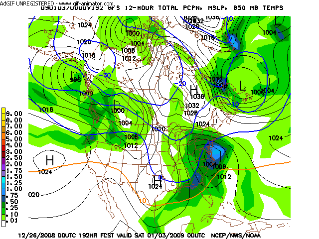
As much as the ultimate track of the storm is always an issue, it will likely not be as significant of a forecast problem for the long range. This is because of the blocking in place, limiting any notable deviation from an east coast track. If anything, the storm may be suppressed to the southeast too much, but a Great Lakes track is unlikely given the concurrent pattern.
Here is an excerpt from the HPC preliminary long range discussion:
I will post more on the January pattern later, as well as a look at February in a few days. For now, I want to focus on a specific day which currently insists on attention: Saturday, January 3, 2009.
Both the Euro and GFS have been indicating for numerous runs the potential for a Miller A/B hybrid affecting much of the east coast on the 3rd.
 The 12z 12/25 ECMWF showed a very strong Miller B sitting off the coast of New England at hour 216 (12z 1/3).
 The 00z 12/26 GFS shows a storm more in tune with the hybrid type I mentioned, and the latest HPC long range D7 map as a blend of the Euro and GFS displays this as well. In addition, with the development of a more west based -NAO, the strong blocking is shown to hold this storm in place near New England for possibly a 24 hour stretch. This is something we have not seen for a long time. We have gotten intense snow storms, and periods of -NAO blocking but its usually too far east, and what results is the 10 to 12 hour bursts of snow (that were a theme of last year). We have not had a classic slow mover in many years. QPF totals of 2" to 2.5" inches over the region is displayed on the 00z GFS.

As much as the ultimate track of the storm is always an issue, it will likely not be as significant of a forecast problem for the long range. This is because of the blocking in place, limiting any notable deviation from an east coast track. If anything, the storm may be suppressed to the southeast too much, but a Great Lakes track is unlikely given the concurrent pattern.
Here is an excerpt from the HPC preliminary long range discussion:
ZONAL FLOW WILL KEEP GENERALLY MILD CONDS THRU MID WEEK UNTIL
COOLER AIR PUSHES EWD WED/THURS. OP MODELS GFS AND ECMWF ARE IN
PRETTY GOOD AGREEMENT ON THE DIGGING SHORTWAVE DRIVING INTO THE MS
VALLEY AND TAKING A NEG TILT LATE FRIDAY INTO SAT. CMC DIGGING ITS
TROF WWD OF GFS/ECMWF AND IN CLOSER AGREEMENT OF LOCATION TO GFS
ENS RUNS RESULTING IN DEEP SRLY FLOW ACROSS ERN CONUS FRIDAY.
PREFERENCE AT THIS TIME IS GFS SERIES AND ECMWF WHICH BOTH CONT TO
INDICATE A PRIMARY OH VALLEY LOW WHICH WILL SHIFT ITS ENERGY TO A
SECONDARY LOW FORMING OFF THE SERN SEABOARD..MILLER TYPE B
CYCLOGENESIS. THIS LOW WILL BEGIN TO DEEPEN OFF THE VA CAPES AND
MOVE NEWD OFF THE NORTHEAST AND NEW ENG COASTS SAT. PCPN TYPE
DETAILS ARE VERY UNCERTAIN AT THIS TIME FRAME ALONG THE COASTAL
PLAIN OF BOTH THE MID ATLC AND NORTHEAST COASTS WITH MODEL RUNS OF
BOTH GFS AND ECMWF HAVING ENOUGH MID LEVEL/TRACK AND THERMAL
DIFFERENCES WITH NEITHER DEEP ARCTIC NOR VERY WARM AIR IN PLACE
OVER THE REGION AHEAD OF THIS SYSTEM TO GIVE A YIELD IN EITHER
DIRECTION. THIS WILL NEED TO BE CLOSELY MONITORED OVER THE NEXT
WEEK AS SOME PARAMETERS ARE MET FOR A SIG WINTER STORM ESPECIALLY
OVER THE NORTHEAST.
Sunday, December 21, 2008
Weekend Summary
A weekend to remember for many. Nothing too unusual necessarily regarding snowfall totals in Keene, for we have had large storms drop similar amounts. However, once this weekend, once it started snowing around 1pm on Friday, it never stopped. We still have snow grains falling under the radar right now, extending the snow streak to 55 hours!
Totals:
For the "Friday storm", accumulations through 1am Saturday: 8.6"
For the "Saturday storm", accumulations through 7am Sunday: 2.5"
For the "Sunday storm", accumulations: 7.4"
Weekend total: 18.5"
---
Delay potential tomorrow: From people that I have talked with around Keene, it sounds like roads are still in poor condition. Some plowing has been done, but roads remain snow covered and slippery. As temperatures plummet tonight, any salt will become ineffective, and any melting due to salting today will freeze. This in addition to winds tonight blowing more snow into the roads I think may make a delayed opening necessary.
My usual methods of delay and cancellation potential are based solely on timing and accumulation during the schoolday of focus. Any other year, I would have low percentages for a delay and a big zero for cancellation. Likely due to the ice storm, this is not a typical year. This can be seen with the cancellations of Friday and Wednesday last week. So with that said, I have notable delay percentages on the board.
Totals:
For the "Friday storm", accumulations through 1am Saturday: 8.6"
For the "Saturday storm", accumulations through 7am Sunday: 2.5"
For the "Sunday storm", accumulations: 7.4"
Weekend total: 18.5"
---
A little less
Flake size continues to suffer, with poor dendritic growth. Rather than building in further west, the precipitation shield has been eroding west of the Connecticut River with a large dry slot moving across western CT and west and central MA. The main plume of moisture to the south of the region will be travelling northeast, affecting portions of eastern Massachusetts and SE NH later today. Jackpot in southern New England will likely be in NE Worcester County and eastern Hillborough country, where precipitation will remain snow while heavy banding moves through. 12+" will be possible in these areas.
In Keene, we'll have to closely monitor the progression the precipitation on radar. It doesnt look too promising and at this point, 6 to 8 inches is a better bet for total accumulation.
---
With these changes, delay potential is also decreased for tomorrow.
In Keene, we'll have to closely monitor the progression the precipitation on radar. It doesnt look too promising and at this point, 6 to 8 inches is a better bet for total accumulation.
---
With these changes, delay potential is also decreased for tomorrow.
Another round of snow
Snow has started to fall across the area (from the current storm: it really never stopped). Currently snow growth is marginal and there are a lot of small dendrites in the mix. The precipitation shield has yet to develop fully, and snow will be showery in nature for the next few hours. Count on accumulation of 2 to 3 inches through noon. After noon, snow will begin to get steadier, and the heaviest snow will likely fall between 2pm and 6pm. This will occur alongside the secondary coastal low rapidly strengthening to our southeast. The NAM has even been advertising the possibility of thundersnow in northern MA and SW NH. Regardless, we'll likely see 1 to 2 inch per hour snow rates during this time. Additional accumulations of 4 to 7 inches will be possible by 6pm. As the secondary low lifts north, how fast it strengthens will determine how much backlash we get. At this time, it looks like snow showers may continue through midnight, with maybe another inch of accumulation. Total accumulation of 7 to 11 inches is expected.
The big story come Sunday night and Monday morning will be the winds. Sustained winds of 15 to 25mph with gusts of 40 to 50mph will be possible after 6pm today as the low pressure rapidly intensifies to around 970mb. For portions of Maine, this will be in time for blizzard conditions tonight. For us, the snow will have shut off, limiting visibility drop. However, the winds will make clean-up difficult as clean streets can quickly become snow covered again as strong winds blow over banks of fresh dry snow.
To our south and east, precipitation type will become an issue for the I95 corridor. A large front-end dump of snow is possible before the changeover however. Places near the coast will be especially susceptable to power outages tonight as winds blow through trees and power lines laden with wet snow and ice.
--- Snowday outlook ---
Falling snow will be over well before timing for a delay or cancellation becomes an issue. However, the winds will have to be monitored, because of the reasoning above that clean streets can quickly become snow covered again. I think the potential still exists for a delay to be necessary for clean-up on Monday.
Friday, December 19, 2008
Heavy snow
Despite a start time about 45 minutes late, heavy snow moved in quicker than anticipated. As of 300pm, 1.7" was on the ground in Keene, 1.4" of which fell in the last hour. Snowfall rates of 1" to 2" per hour will continue through the afternoon. Flake size has been marginal and may reduce ratios a little. Also, currently watching a dry slot in central NY and PA. A moist low level jet should give us several hours more of precipitation, but still something to watch. Based on radar in E PA and N NJ, some very heavy snows likely particularly between 5pm and 7pm for portions of Massachusetts. This is the timeframe that a few reports of thundersnow will be possible. For Keene, currently thinking 4.5" by 5pm, 7" by 7pm, before the heaviest snow moves out.
Thunder and Lightning
An excellent display of a very dynamic system heading towards the region right now. Looking at reports upstream, there have been lightning strikes from Illinois into Ohio and Michigan. This along with latest mesoscale model runs indicating a good environment for frontogenesis along the Mass Pike supports the possibility of strong banding and thundersnow this evening. Snow could fall at rates of 2 to 4 inches per hour in central Massachusetts around 5pm to 8pm.
Here in Keene, still no changes. Model guidence supports at least .7" water equivalent now. This adds confidence to the possibility of 10" here. Will continue to monitor radar trends to see whats ahead. For now, no significant deviations from the expected.
---
Sunday is looking good still. Will have a full discussion and first map later today.
Snow arriving around noon
A cancellation? ...
Anyway, previous forecast still on track. Snow will start to fall by 11am to noon, and become heavy after 1pm. Count on 1" to 1.5" on the ground by 2pm. After that it will get heavy, with snowfall rates of an 1" to 1.5" per hour between 3pm and 7pm. Snow will begin to lose intensity after 7pm, however will continue falling through midnight. Total accumulation of 7" to 10" is still on track.
---
I'll have more about Sunday and Sunday Night later today as well (since I have some time to spare once again).
Thursday, December 18, 2008
A tale of two storms
New England will be rocked by two fast moving winter storms. The first one will arrive tomorrow afternoon with widespread 8 to 12 inches across SNE with locally up to 18 inches along and south of the Mass Pike.
The second storm will be much stronger. A secondary low will draw energy from a lakes cutter on Sunday, rapidly intensifying near Cape Cod. This storm will yield greater precipitation type issues in the I95 corridor, however the interior, and northern New England could get hit very hard with 8 to 16 inches of snow, and possible blizzard conditions north of Concord, NH.
For all the details, visit the Winter Weather Outlook
Final call for Friday

Timeline:
12pm - Snow begins to fall.
2pm - <1" accumulation. Moderate snow.
4pm - 1" - 2" accumulation. Heavy snow.
6pm - 3" - 4" accumulation. Heavy snow.
8pm - 5" - 6" accumulation. Heavy snow.
10pm - 6" - 8" accumulation. Moderate snow.
12am - 7" - 9" accumulation. Light snow.
2am - 7" - 10" accumulation. Chance light snow.
Additional accumulation around an inch will be possible during the day Saturday as easterly flow supports the continuation of bands of light snow across the region.
Second, Sunday

Another storm system will move in quickly right behind the storm tomorrow. This one has more energy out west right now, and will rotate into the midwest, with surface low pressure moving across the central plains Saturday morning. 500mb vorticity max wraps around the east side of the negative tilting H5 low Saturday night. High pressure to our north will be weakening and retreating. This will allow the deepening surface low pressure to cut north to the Great Lakes. Secondary low pressure will develop inside the benchmark Sunday morning and rapidly strengthen with energy transfer from the primary low.
High pressure will still be present enough to reinforce cold air for at least interior New England. Right now precipitation type issues are certain for the I95 corridor where snow changing to a wintry mix, and rain is likely, before changing back to snow Sunday night. NW of I95, into central MA, a wintry mix is likely Sunday, with another round of significant ice accretion possible for some of the same areas devastated last week. This will have to be watched carefully. In Keene, current model forecast thicknesses suggest precipitation should stay all snow.
QPF looks like a general .5+" across all of New England, with highest amounts towards the north. In Keene, looking at .8" to 1.0" for water equivalent right now. If the secondary low gets going earlier, could be talking about more. Right now we may get an hour or two of wrap around precipitation Sunday night, but if the low can develop / strengthen quicker, back end snows could be more significant.
Current forecast for snowfall Sunday into Sunday night: 7" to 12"
In addition to snow, the rapid deepening of the secondary low could develop a very tight pressure gradient across northern New England. Blowing and drifting snow will be possible Sunday night into Monday down into southern NH with even blizzard conditions possible further north.
South trend done
The NAM continues to shift back north, proving once again not to take it very seriously. General consensus stands for .5 to .6" w.e. Considering high ratios, this would result in 7 to 10 inches.
My latest thoughts for Keene are 6 to 9 inches of snow.
My latest thoughts for Keene are 6 to 9 inches of snow.
Wednesday, December 17, 2008
00z NAM
As expected, dramatically higher QPF over SNE versus the 18z run. I think the 18z run can safely be tossed. 00z NAM gives Keene about .5" of water equivalent. With excellent omega, even on the edge of the storm, and a cold thermal profile, we'll be seeing high ratios, around 16:1. Down to the Mass Pike, ratios as high as 20:1 will be possible which will allow a few areas to reach 18 or more inches.
Sunday into Monday holds a lot of potential. Low pressure will track closer to the region, so ptype issues are likely in the I95 corridor. A very good set up at this point for a foot of snow here and maybe some winds as well as the low rapidly deepens to our east. Snow should wrap up before dawn Monday. I still haven't had time to write up a discussion, but maybe tomorrow...
Sunday into Monday holds a lot of potential. Low pressure will track closer to the region, so ptype issues are likely in the I95 corridor. A very good set up at this point for a foot of snow here and maybe some winds as well as the low rapidly deepens to our east. Snow should wrap up before dawn Monday. I still haven't had time to write up a discussion, but maybe tomorrow...
Snowfall forecast map

For Friday - basically not much change from my previous post. 5" to 8" is looking like a good bet here right now. The 18z NAM is wicked south, as in 2 to 3 inches here, and jackpot across N PA and N NJ! But Im throwing that one out for now, and just accepting that a southward shift has taken place, but not as significant as the NAM. A few spots in the 10+ area could see 18" by Saturday morning. This is all in about a 10 hour window.
Friday, trending south
After a dismal winter last year, perhaps this year will be nicer to those to our south. Model guidence is trending stronger with high pressure to our north, with a flatter wave that heads further south. As I said before, QPF will be the main issue here in Keene, and as it turns out it will be a huge issue. In fact, at this point, with the 12z ECMWF following the GFS and NAM with their continued shifts south, north of the Mass Pike will probably struggle to reach double digit accumulations.
To the south of the pike, accumulations between 10 and 18 inches will be possible, and it looks more and more like NYC could get in on the action as well, probably scoring more snow than we do. Ptype issues may only affect the south coast of New England inland a couple miles as 850mb temperatures remain below freezing for all of SNE. Otherwise, the strong high pressure to our north will secure a very cold airmass, with surface temperatures struggling to reach 20 in Keene on Friday, and 850mb temps under -10C.
Here are QPF GFS and NAM outputs for KEEN:
12z NAM: .43"
12z GFS: .66"
This translates to snowfall in the 5 to 8 inch range.
At this point, I am moved to bring my forecast back down to the 5" to 9" I had before. Continued adjustments will be likely. If the south trend continues, we could have less. I'll try to whip up a map later on.
Model guidence has also trended a little slower with the storm and onset of precipitation may not be until the afternoon. Cancellation potential has diminished significantly.
Coming up today
Keene schools closed for today, which is a little surprising, but I suppose it may be to accommodate the clean up efforts in the out-lying towns.
Anyway, with some extra time today, I'll be able to post some more information regarding Friday and Monday (Sun-Mon). I plan to get a full Friday forecast out later this morning, and I'll write up a discussion for Monday's storm this afternoon.
Stay tuned. It's still looking good.
Anyway, with some extra time today, I'll be able to post some more information regarding Friday and Monday (Sun-Mon). I plan to get a full Friday forecast out later this morning, and I'll write up a discussion for Monday's storm this afternoon.
Stay tuned. It's still looking good.
Tuesday, December 16, 2008
First, Friday
The ECMWF and GFS have amazingly had a rather steady forecast for a major winter storm on Friday. This helps to add confidence in the forecast of heavy snow across much of New Enland into NY, and PA.
A large and strong piece of energy currently sitting off of the California coast, will rotate south and then east into the southwest states by Thursday morning. As the -EPO jet intensifies out west, high pressure will be pulled southward into central Manitoba, and then into Ontario by Thursday night.
Strong high pressure to our north is the key, and will in fact keep temperatures 5 to 10 degrees below the normal through the duration of the event. This will guarentee precipitation type as snow at least north of the Mass Pike. Here in Keene, with surface temperatures of 23 to 28 during the day Friday, and 10 to 15 Friday Night, I do not foresee mixing being an issue at all (which is definitely a unique senario considering this past winter, and this month so far). South of the Mass Pike, sleet could be an issue, and getting down toward NYC, precipitation may change to rain towards the end of the storm. This would still be after a decent sized front end dump of snow.
Surface low pressure will develop Thursday and intensify as it heads into the southern Lakes region by Friday morning. With the strong high pressure to the north, boundary layer cold air will be kept in tact. There will be a tight 850mb temperature gradient, with temperatures near 0C across northern NJ, -10C close to Keene, and -20C temperatures entering northern Maine. Overrunning warm air will cause precipitation to develop over the region Friday morning. With high Q-vector convergence suggesting areas of strong ascent with omega as much as -15 to -20ub/s, precipitation intensity will increase rapidly. Combined with high PWAT values, snowfall rates of 1 to 3 inches per hour will be possible during the day Friday. This will however be a fast mover however, and should be done within 12 hours of its arrival.
Model guidence is uniform in showing widespread .75+" QPF, with areas up to 1.5" with thermal profiles still favorable for snow. Even the GFS ensemble mean show a 99mb low with QPF maximum of 1.25 to 1.5" across CT. QPF looks like the main forecasting issue. Not that there is considerable disagreement among model guidence, just that the placement of maximum water equivalent will dictate whether we get 4 inches of snow or 18 inches of snow. At this point, I am comfortable using 4 inches as a bare minimum.
The GFS, GGEM, and ECMWF have been suggesting a wide stripe of 6 to 12 inches with upwards of 18 inches.
At this time, I think 6" to 12" is an appropriate forecast for Friday morning through Friday Night.
---
Doesn't stop there. Another major storm is possible on Monday. I probably will not have time to post on this tonight though.
Faster tomorrow, Watching Fri, Mon
General model consensus along with radar trends indicates snow may move into the area a little faster, likely beginning around 1am in Keene, and peaking between 5am and 7am. An inch could be on the ground by 4am, with another 1 to 2.5 inches between 4am and 7am. Light snow will continue through mid morning, with another 1 to 1.5 inches likely, then change to sleet and light freezing rain before ending by 2pm. No ice accretion is expected. Total of 3 to 5 still looks right.
---
Friday and Monday still look very good. Between the GFS and ECMWF combo (12z Euro looks amazing by the way), I have good confidence in 6+" accumulations with both storms. Details will be posted later tonight.
---
Friday and Monday still look very good. Between the GFS and ECMWF combo (12z Euro looks amazing by the way), I have good confidence in 6+" accumulations with both storms. Details will be posted later tonight.
Final thoughts for tomorrow
SREF ensembles are a little drier, and the NAM is slowly returning to reality. Still thinking 3 to 5 inches for a total. There is a good consensus for 1.5 to 2 inches by 7am, again, with peak snowfall rates between 5am and 8am. This could require a delay tomorrow morning. Snow will continue through the morning, but with dendritic growth lacking, snowfall rates will be light. An addition 1 to 2 inches will be possible between 7am and 10am with another .5 to 1" after 10am. After 1pm, mid level warmth (850-700mb thickness around 1550m) will cause snow to mix with and change to light sleet and freezing rain. A light glaze of ice accretion is possible, but likely nothing measurable, and precipitation should shut off by 4pm.
A summary of the next 3 events
1) Wednesday - Snow will start after 2am Wednesday, and fall at a light to moderate clip through dawn. Accumulations of 1 - 2 inches can be expected by 6am. As mid level temperatures warm, snow may begin mixing with sleet late Wednesday morning before tapering off Wednesday afternoon. Total accumulations of 3 to 5 inches can be expected. >The exact timing of the event will dictate if a delay or cancellation is needed. For a cancellation, an couple more inches would be required. At this point, with the peak of the event possibly occuring during the morning commute, a delay may be necessary.<
2) Friday - A much stronger system will move towards the region Thursday Night. Temperature profiles indicate this could be snow for most of the region at least in the beginning. Significant accumulations appear likely at this time. Currently thinking 5 to 9 inches is possible. >The timing of the event will be centered during the day Friday, so a cancellation is looking promising at this time.<
3) Monday (22) - A strong storm system will cut north to the Great Lakes region, while high pressure remains intact to our north. Secondary low pressure may develop to the south of the region. The GFS and ECMWF both advertise a very intense storm with heavy precipitation and strong winds. At this time, it looks like mainly snow north of the Mass Pike. In that case, we would be talking about another 6+" easily.
So, a busy 7 days ahead of us. Stay tuned.
Monday, December 15, 2008
Wednesday looking more promising
The models are closing in on a snowy forecast for much of New England on Wednesday.
Precipitation will come in two pulses with this event. The first pulse will be south of the second one. The NAM wants to place the axis of heaviest snow across CT and RI, with significant accumulations across PA and NJ as well. While there is still some variance and the NAM is towards the south side of the guidence, the strength of high pressure to the north and the established cryosphere in the northeast should help push the cold air and precipitation south. The second pulse will move in after 3am Wednesday. This one will be stronger and move SW to NE across the region on Wednesday. The placement of this wave will be further north, and will probably offer us the best chances for decent accumulation. Precipitation type is currently not much of an issue here in Keene (basically places north of Rt 2). Mid level warming will not reach full strength here, and at most may introduce some sleet mixing in with the snow. Precipitation will wind down Wednesday evening. The models have trended wetter for this storm, with water equivalents over .5".
SREF probabilities for Keene puts 12hr 1+" at 100%, 2+" at 61.3%, and 4+" at 41.8% which is not bad at all.
Currently thinking 3" - 6" here in Keene.
---
Stay tuned for more on this storm, Friday's storm, and Monday's (22) storm.
A Mega Front
Low pressure moving northeast through Ontario is dragging a cold front to its south that is openning the doors to a major arctic blast in the upper plains with record low temperatures. Out ahead of it, surface temperatures are approaching record highs. In fact, some places approach both within a 24 hours period. Here is the daily climate summary for Ottumwa, IA for December 14, 2008:
That's a 58 degree drop in just 12 hours.
Taking a look at temperatures across the nation this morning, you can see the contrast: 50's and 60's east of the boundary, and temperatures below zero, as low as -30, west of the boundary.

The cold front will lose some strength as it heads east, and it will stall south of the region tomorrow. The cold air mass will not be quite as intense in the east, but will be enough to keeps temperatures about 5 degrees below the normal for this time of year.
Actual...           Record...
MAXIMUM 61 1157 AM  62 1908
MINIMUM 3 1159 PM  -10 1989
That's a 58 degree drop in just 12 hours.
Taking a look at temperatures across the nation this morning, you can see the contrast: 50's and 60's east of the boundary, and temperatures below zero, as low as -30, west of the boundary.

The cold front will lose some strength as it heads east, and it will stall south of the region tomorrow. The cold air mass will not be quite as intense in the east, but will be enough to keeps temperatures about 5 degrees below the normal for this time of year.
Overrunning
We have a wintry week ahead of us that is similar in some respects to last winter. With a frontal boundary draped from SW to NE south of the region tomorrow, waves of low pressure will travel up along the boundary into the region. With high pressure to our north, boundary layer cold temperatures will be locked in place. The frontal boundary will oscillate north and south with the waves with warm air advection occuring in the mid levels. This act of warm air moving in over an established cold air mass at the surface is refered to as overrunning and can trigger steady precipitation. The exact positioning of the front and magnitude of the warm air advection dictates the precipitation type, however these set ups are often conducive to ice events.
Currently, there are two events to be watched this week: Wednesday and Friday.
On Wednesday a weak low pressure system will redevelop south of New England with some light to moderate precipitation overspreading the region. Temperatures will be cold enough to support all snow at least north of route 2, while icing becomes an issue further south. Water equivalents will range between .2" and .4" in the north with up to .6" over CT and RI (closer to the front). The main time period of snow here in Keene will be between 10am and 6pm, although the exact timing still needs to be ironed out a little. Total accumulations of 2 to 3 inches will be possible with this storm.
On Friday, a much stronger storm system will move across the Great Lakes region. With high pressure intact to our north, cold air reinforcement will keep precipitation in the form of snow at the onset, then changing to sleet and freezing rain during the day on Friday. Water equivalents could be much higher with this system and offer a potentially significant winter storm.
In addition to these separate events, clouds and light precipitation could be ongoing through Thursday as well as the front remains near the region.
More details later...
Sunday, December 14, 2008
A look at next week (Dec 14 - 20)
A strong storm system will lift into Ontario tomorrow morning and northern Quebec tomorrow evening. Southerly flow will transport much warmer temperatures into the region out ahead of the storm with highs reaching the 50's across all of SNE.
An associated cold front will cross the eastern states Monday night, with rain showers likely Monday evening through Tuesday morning. Much colder temperatures (around normal) will move back into the northeast for Tuesday, with some light snow showers possible in the morning (no accumulation).
The front should begin to stall south of New England as flow becomes parallel to the boundary. This front then presents itself as a baroclinic zone for storms to develop and track along.
Ironically, we could be entering a more favorable period for snow accumulation despite a +NAO / -PNA (trough-west, ridge-east) set up. This is because we still have a -EPO resulting in split flow in the west, and the SE ridge temperature correlation diminishes up towards New England.

What happens now is storms develop in the SW along the southern jet, assisted by energy transport south from the Gulf of Alaska, then move NE toward the Great Lakes and New England region. The fast flow across the central US prevents shortwaves to amplify significantly, and consequently keeps strong ridging (and blowtorch temperatures) from building in the east. The northern jet recombines with the southern jet in SE Canada and this confluence encourages development of an arctic high. The high pressure in southern Canada causes cold air damming in the northeast. This is again a recipe for ice storms. However, if the storms are not as amplified, mid level temperatures may still be cold enough for snow north of Route 2, and wintry mixes further south.

Back to this week, we will be seeing a couple opportunities for storms like the above mentioned. The first on Wednesday, and another on Friday. Both of these will be discussed in the Winter Weather Outlook page.
Going into week 2, the 12z ECMWF advertises a major storm system cutting across the Great Lakes next Sunday (with SE Canadian high pressure in tact). This could be a third wintry threat for the region. But besides that, it could open the doors to below normal temperatures in Canada streaming into the midwest behind the storm, and maybe a temporary shot of cold air in the east.
POWERLESS
...To quote the very appropriate Keene Sentinel headline on Friday.
I personnally just got power back at 9:30 this morning totalling 54 hours without electricity. This was no doubt an inconvenience, but it is nothing compared to the time that many in central NH down into central MA will have to deal with.
From the Sentinel:
Storm summary: Ice accretion was very elevation dependent. While my backyard at 1000ft in Keene recorded .6" of ice, downtown Keene at 500ft only had a light glaze. In addition, it was the eastern slopes that had the worst ice accumulation up to an inch from central NH into central MA. In addition to ice, rainfall between 2.5 and 6 inches raised many rivers over their banks in SNE. Winds on the backside of the storm gusted between 30 and 50mph, largely contributing to the historical outages.
---
Moving on, because the weather never pauses, after a very cold day yesterday, temperatures will rise into the 30's today, and around 50 on Monday with some rain. After a frontal passage on Tuesday, much colder temperatures will return, with a round of snow and ice likely Wednesday.
I personnally just got power back at 9:30 this morning totalling 54 hours without electricity. This was no doubt an inconvenience, but it is nothing compared to the time that many in central NH down into central MA will have to deal with.
From the Sentinel:
About 1.3 million homes and businesses from Pennsylvania to Maine were plunged into the dark, and cold, by the storm that coated trees and wires with ice Thursday night into Friday. Most of the outages were in New Hampshire, Massachusetts, Maine, and New York. Nearly 880,000 remained without power Saturday afternoon. At the peak Friday, more than 460,000 customers lost power in New Hampshire, the worst power outage in state history. About 368,000 still were in the dark Saturday afternoon. Another 35,000 lost power in Massachusetts, down to about 200,000 Saturday. About 311,000 customers were knocked out in upstate New York, with at least 185,000 still without power Saturday. About 170,000 of the quarter million affected in Maine still were in the dark Saturday. Vermont utilities reported just under 14,000 customers remained without power Saturday afternoon, down from about 40,000. About 4,400 homes and businesses in northwestern Connecticut without power, down from 16,500. Neaerly all 11,000 outages in northeastern Pennsylvania were restored by Saturday.
Storm summary: Ice accretion was very elevation dependent. While my backyard at 1000ft in Keene recorded .6" of ice, downtown Keene at 500ft only had a light glaze. In addition, it was the eastern slopes that had the worst ice accumulation up to an inch from central NH into central MA. In addition to ice, rainfall between 2.5 and 6 inches raised many rivers over their banks in SNE. Winds on the backside of the storm gusted between 30 and 50mph, largely contributing to the historical outages.
---
Moving on, because the weather never pauses, after a very cold day yesterday, temperatures will rise into the 30's today, and around 50 on Monday with some rain. After a frontal passage on Tuesday, much colder temperatures will return, with a round of snow and ice likely Wednesday.
Thursday, December 11, 2008
Sleet over
The sleet should be over for lower elevations now as 850mb WAA has surged over Cheshire County, with a very tight gradient of 0C to 4C north to south. From here on out the precipitation will be in the form of freezing rain. Significant ice accretion is possible through 3am. After 3am, some low lying areas may begin to switch to plain rain as surface temperatures hit just above freezing. Higher elevations will likely maintain sleet or freezing rain.
Sleet
Over the last half hour, precipitation has changed to mostly sleet over Cheshire County. The snow line has been pushing south some, and northern Cheshire County including Marlow, and Alstead, could pick up 1 to 3 inches of accumulation tonight. The snow accumulation gradient will be tight, with Lempster likely to receive close to 5 inches and Unity up to 7 inches.
Winds have shifted to the north in the last hour at KEEN, which is a good indication of reinforcing low level cold. Temperatures have been steady across Cheshire County at 28 to 32. Sleet and freezing rain will likely trade back and forth in dominance through midnight. Total sleet accumulation will be around an inch to an inch and a half.
Winds have shifted to the north in the last hour at KEEN, which is a good indication of reinforcing low level cold. Temperatures have been steady across Cheshire County at 28 to 32. Sleet and freezing rain will likely trade back and forth in dominance through midnight. Total sleet accumulation will be around an inch to an inch and a half.
Freezing rain intensifying

Surface temperatures range from 28 to 32 across Cheshire County currently, with precipitation types generally freezing rain or freezing rain and sleet. Precipitation will increase in intensity through midnight as the warm front pushes north and west across SE MA. Surface temperatures will remain steady, possibly falling a degree through midnight. Precipitation type could trend more toward sleet by midnight. By 3am, warm air advection will begin affecting the surface, pushing temperatures back up a degree or two. This may change precipitation to plain rain in lower elevations while higher elevations maintain sleet through the morning.
636 PM EST THU DEC 11 2008

...ICE STORM WARNING REMAINS IN EFFECT UNTIL 7 AM EST FRIDAY...

AN ICE STORM WARNING REMAINS IN EFFECT UNTIL 7 AM EST FRIDAY.

THE WARNING COVERS ALL OF CHESHIRE AND HILLSBOROUGH COUNTIES WITH
MAJOR IMPACT LIKELY IN THE MONADNOCKS.

FREEZING RAIN WILL FALL HEAVILY AT TIMES WITH GLAZING EASING AT
DAWN AS TEMPERATURES RISE TO AROUND FREEZING.

HEAVY ACCUMULATIONS OF GLAZE WILL PROBABLY CAUSE POWER OUTAGES BY
MIDNIGHT TONIGHT WITH AREAS OF 1 INCH THICK ICE ON TREES AND
WIRES...ESPECIALLY THE EAST FACING SLOPES OF THE BERKSHIRES.

SLEET MAY BRIEFLY BE MIXED WITH THE FREEZING RAIN THIS EVENING.

UNTREATED ROADS AND WALKWAYS ARE ALREADY BECOMING ICY. IF
TRAVELING YOU SHOULD ALLOW PLENTY OF EXTRA TIME TO REACH YOUR
DESTINATION.

THIS IS A POTENTIALLY DANGEROUS SITUATION WITH LONG DURATION
POWER OUTAGES POSSIBLE...ESPECIALLY THE MONADNOCK REGION.
To add insult to injury...
 While we get bombarded by ice and start to lag well behind our normal snowfall for the season, the SOUTH is doing JUST FINE!
On the back side of this strong southern system, much colder air was pulled south. Along with a deformation zone developing a band of 1" to 2" PER HOUR snowfall rates, Portions of southeastern Texas into Louisiana including NEW ORLEANS received 1" to 6" of snow last night and this morning. To the left is a webcam picture from BATON ROUGE, LA
PUBLIC INFORMATION STATEMENT...CORRECTED
NATIONAL WEATHER SERVICE HOUSTON/GALVESTON TX
1158 AM CST THU DEC 11 2008

...SNOW FALL TOTALS FOR 10 DECEMBER 2008...

A COLD UPPER LEVEL LOW PRESSURE SYSTEM MOVED ACROSS SOUTHEAST
TEXAS YESTERDAY AND HAS PRODUCED A BROAD AREA OF SNOWFALL FOR
EARLY DECEMBER. THIS TIES THE MARK FOR THE EARLIEST SNOW FALL IN
THE HOUSTON AREA FOR DECEMBER. IT HAD ALSO SNOWED ON DECEMBER 10
IN 1944. LIGHT SNOW FELL DURING THE MORNING OVER PARTS OF
WASHINGTON...BURLESON AND BRAZOS COUNTIES ON DECEMBER 10TH. SNOW
REDEVELOPED DURING AFTERNOON AS THE UPPER LEVEL LOW PRESSURE
MOVED INTO THE HOUSTON AREA. SOME AREAS ACROSS THE REGION SAW A
CHANGE OF RAIN AND SLEET TO SNOW BY THE EVENING HOURS. SNOWFALL
WAS AT ITS HEAVIEST BETWEEN 5 PM AND 10 PM LAST NIGHT MAINLY EAST
OF AN INTERSTATE 45 LINE. SNOW FALL AMOUNTS RANGED FROM A TRACE
OVER PARTS OF WESTERN BRAZORIA...HARRIS AND MONTGOMERY COUNTIES
TO AS MUCH 2 TO 3 INCHES IN EASTERN HARRIS COUNTY. TRACE TO ONE
INCH AMOUNTS FELL ON GALVESTON ISLAND WITH GENERALLY AN INCH TO
TWO INCHES OF SNOW FALL FOR GALVESTON COUNTY. THE HEAVIEST SNOW
FALL WAS IN A BAND FROM CHAMBERS COUNTY TO POLK COUNTY WHERE
SOME AREAS SAW AS MUCH AS 4 TO 5 INCHES OF SNOW. BELOW ARE THE
LATEST SNOW FALL TOTALS FOR SOUTHEAST TEXAS:

...BRAZOS...BURLESON...MADISON...HOUSTON COUNTIES...
COLLEGE STATION - 1.5-2 INCH
EASTERWOOD FIELD KCLL - 2.0 INCH
BRENHAM - 3 INCH
MADISONVILLE - 2-3 INCH
HOUSTON COUNTY - 1.0 INCH
CONROE - 1.2 INCH
NAVASOTA - 2.0 - 3.0 INCH

...HARRIS COUNTY...
KINGWOOD - 1.0 INCH
HOUSTON INTERCONTINENTAL - TRACE
CYPRESS - 0.5 INCH
DW HOOKS FIELD - TRACE
SPRING - 1.0 INCH
RICE/WEST U - 0.5 INCH
HOUSTON HOBBY AIRPORT - 0.3 INCH
PASADENA - 2.5 INCH
CHANNELVIEW - 2.5 INCH
LA PORTE - 3.0 INCH
BAYTOWN - 4.0 INCH
HOUSTON (SE) - 0.5 INCH
ELLINGTON FIELD KEFD - 1.0 INCH

...GALVESTON...BRAZORIA COUNTIES...
GALVESTON - 1.0 INCH
CLEAR LAKE - 1.0 INCH
NWS OFFICE - 1.5 INCH
LEAGUE CITY - 1.5 INCH
PEARLAND - 0.5 INCH
SEABROOK - 1.0 INCH
SANTA FE - 2.0 INCH
SWEENY - 0.5 INCH
ANGLETON - 0.5 INCH

...CHAMBERS...LIBERTY...POLK...SAN JACINTO...TRINITY COUNTIES...
TRINITY - 1 INCH
LIVINGSTON - 2.0 INCH
SAN JACINTO COUNTY - 2.5 - 3.0 INCH
MOUNT BELVIEW - 5.0 INCH
LIBERTY - 5.0 INCH
ANAHUAC - 4.0 INCH
WINNIE - 5.0 - 6.0 INCH

WHEN DID IT SNOW LAST? SNOW FLURRIES FELL ACROSS THE EXTREME
NORTHERN PARTS OF THE REGION ON MARCH 7TH 2008 BUT THE LAST
MEASURABLE SNOW OCCURRED ON APRIL 7TH 2007 NORTH OF A CALDWELL TO
LIVINGSTON LINE. ONE TO TWO INCHES OF SNOW FELL ON THAT SATURDAY
BEFORE EASTER.

THE LAST MEASURABLE SNOW TO FALL IN THE HOUSTON AREA FELL ON
CHRISTMAS EVE IN 2004. SNOW AMOUNTS WERE A TRACE AT
INTERCONTINENTAL AIRPORT...BUT SOUTHERN SUBURBS LIKE PEARLAND...
WEBSTER AND CLEAR LAKE RECEIVED 2 TO 3 INCHES OF SNOW. FURTHER
SOUTH A BAND OF HEAVY SNOW AFFECTED WHARTON...FORT BEND AND
BRAZORIA COUNTIES.

FOR WHAT IT`S WORTH...THE LAST LAND FALLING HURRICANE ON GALVESTON
ISLAND BEFORE HURRICANE IKE WAS HURRICANE JERRY IN 1989. THERE
WAS 1.7 INCHES OF SNOW ON DECEMBER 22 1989. HURRICANE ALICIA MADE
LANDFALL IN 1983 AND THERE WERE SEVERAL DAYS WITH SNOW FLURRIES IN
DECEMBER OF 1983. PERHAPS JUST A COINCIDENCE.
Low pressure in W North Carolina


The storm system continues to wind up in the southeast. The current satellite imagery shows the magnitude of the storm very well. Decent cold air damming at the surface continues to hold freezing temperatures down to Route 2. Tonight, areas along and north of Route 2 will likely be the zone of maximum icing. 850mb temperatures are at 0C just north of Keene now. This boundary marks about where more sleet than freezing rain will fall. North of the -2C isotherm is where the maximum snowfall will occur.
On radar, you can see the heaviest precipitation has yet to move into the region. This will all shift into the region tonight. Freezing rain, mixed at times with sleet will fall through the night. Another .5" to .75" of ice accretion (up to an inch above 1000ft) with 1 to 2 inches of sleet accumulation is possible through dawn tomorrow.
Ice Storm Warning
URGENT - WINTER WEATHER MESSAGE
NATIONAL WEATHER SERVICE TAUNTON MA
420 PM EST THU DEC 11 2008

...MAJOR WINTER STORM TODAY AND TONIGHT...

.COLD HIGH PRESSURE WITH ITS RESERVOIR OF SUBFREEZING TEMPERATURES HAS
BECOME ENTRENCHED FROM NEW YORK STATE TO NORTHERN NEW ENGLAND AND
SOUTHEAST CANADA TODAY. LOW PRESSURE MOVING TOWARD NEW ENGLAND FROM
ASHEVILLE NORTH CAROLINA LATE THIS MORNING WILL CONSTANTLY DRAW UPON
THAT POOL OF COLD AIR TO OUR NORTH WHILE HEAVY PRECIPITATION FLOWS
NORTHWARD WITH THE MOISTURE LADEN LOW PRESSURE CENTER. THIS WILL
RESULT IN A MAJOR ICE STORM FOR PORTIONS OF INTERIOR SOUTHERN NEW
ENGLAND...PARTICULARLY NORTHERN WORCESTER COUNTY INTO THE MONADNOCKS.
THE LOW PRESSURE GALE CENTER WILL MOVE ACROSS EASTERN MASSACHUSETTS
FRIDAY MORNING AND DEPART FOR THE MARITIMES IN THE AFTERNOON.

NHZ011-012-015-120530-
/O.CAN.KBOX.WS.W.0010.000000T0000Z-081212T1200Z/
/O.EXA.KBOX.IS.W.0002.000000T0000Z-081212T1200Z/
CHESHIRE NH-EASTERN HILLSBOROUGH NH-
WESTERN AND CENTRAL HILLSBOROUGH NH-
INCLUDING THE CITIES OF...JAFFREY...KEENE...MANCHESTER...NASHUA...
PETERBOROUGH...WEARE
420 PM EST THU DEC 11 2008

...ICE STORM WARNING IN EFFECT UNTIL 7 AM EST FRIDAY...
...WINTER STORM WARNING IS CANCELLED...

THE NATIONAL WEATHER SERVICE IN TAUNTON HAS ISSUED AN ICE STORM
WARNING...WHICH IS IN EFFECT UNTIL 7 AM EST FRIDAY. THE WINTER STORM
WARNING HAS BEEN REPLACED BY THE MORE DEFINED ICE STORM WARNING.

THE WARNING COVERS ALL OF CHESHIRE AND HILLSBOROUGH COUNTIES WITH
MAJOR IMPACT LIKELY IN THE MONADNOCKS.

FREEZING RAIN WILL FALL HEAVILY AT TIMES WITH GLAZING EASING AT DAWN
AS TEMPERATURES RISE TO AROUND FREEZING.

HEAVY ACCUMULATIONS OF GLAZE WILL PROBABLY CAUSE POWER OUTAGES BY
MIDNIGHT TONIGHT WITH AREAS OF 1 INCH THICK ICE ON TREES AND WIRES...
ESPECIALLY THE EAST FACING SLOPES OF THE BERKSHIRES.

SLEET MAY BRIEFLY BE MIXED WITH THE FREEZING RAIN THIS EVENING.

UNTREATED ROADS AND WALKWAYS ARE ALREADY BECOMING ICY. IF TRAVELING
YOU SHOULD ALLOW PLENTY OF EXTRA TIME TO REACH YOUR DESTINATION.

THIS IS A POTENTIALLY DANGEROUS SITUATION WITH LONG DURATION
POWER OUTAGES POSSIBLE...ESPECIALLY THE MONADNOCK REGION.

AN ICE STORM WARNING IS ISSUED FOR ICE ACCRETION OF ONE HALF INCH
OR GREATER. TRAVEL WILL BE EXTREMELY DIFFICULT.  ICE ACCRETION
COULD RESULT IN DOWNED TREE LIMBS AND POWER LINES. IF YOUR POWER
GOES OUT...DO NOT USE CANDLES. HAVE BATTERIES AND FLASHLIGHTS ON
HAND.  IF YOU MUST TRAVEL...KEEP AN EXTRA FLASHLIGHT...FOOD...AND
WATER IN YOUR VEHICLE IN CASE OF AN EMERGENCY.
Ice Storm


Jaffrey, Rindge, Conval - all closed ... Not Keene? Why not? Maybe because there is concern that with a cancellation tomorrow, that's two days off in a row. Can't have that regardless of if there is already a tenth inch of icing, a winter storm warning in effect, and much more to come this afternoon. No, we can't have a cancellation, because it would be much safer to head onto the roads at 2pm to 3pm with steady sleet and freezing rain and untreated roads literally unnavigable.
Sarcasm over...
Anyway, moderate sleet and freezing rain will continue through the day, with up to .25" ice accretion and an inch of sleet possible by 3pm. After 3, precipitation will begin to increase in intensity as the coastal storm moves northward. Precipitation will fall heavy at times through tonight. Up to an inch of ice accretion, and 2 to 3 inches of sleet will accumulate by dawn. As the low moves to our northeast Friday morning, sleet and freezing rain will change to sleet and snow, and could add 2 to 3 inches of snow on top of the 4 inches of sleet / freezing rain combination.
Unless the forecast is off, which it was not this morning, I would not understand how we would not have AT LEAST a delay tomorrow.
For the latest on the storm check The radar and satellite center
Sleet
Temperatures have fallen into the upper 20's to near 30 across Cheshire County this morning and will remain steady around 30 for the rest of the day. Sleet moved into the area in the last hour, and has already begun to accumulate. Sleet and freezing rain will intensify through the morning and afternoon, with sleet accumulation of 1 to 2 inches possible. On radar, precipitation appears showery. This will act to accelerate ice accretion, as there will be less run off, and a far greater precentage will freeze instantly. Road conditions will deteriorate through the morning and afternoon.
---
Closings:
Recently in is Conval Regional School District in Hillsborough County.
---
Closings:
Recently in is Conval Regional School District in Hillsborough County.
Wednesday, December 10, 2008
Cold air moving in


A good cold air damming signature is showing up with northerly ageostrophic wind flow starting to push colder boundary layer temperatures further south. The second image depicts 850mb temperatures which will be important for determining snow versus sleet versus freezing rain. As you can see, a very tight gradient is present. This gradient should push south through tonight.
Any precipitation that falls later tonight will likely be in the form of sleet or rain. No accumulations are expected though tomorrow morning.
Freezing rain, sleet, and snow will start to fall tomorrow around 9am, and ice accretion with some light snow and sleet accumulation as well will be likely by noon, quickly making travel difficult.
Winter Storm Warning
URGENT - WINTER WEATHER MESSAGE
NATIONAL WEATHER SERVICE TAUNTON MA
419 PM EST WED DEC 10 2008

...WINTER STORM POSSIBLE THURSDAY AND THURSDAY NIGHT...

.A STRONG COLD FRONT CROSSES SOUTHERN NEW ENGLAND THIS EVENING. COLD
HIGH PRESSURE SPREADS OUT ACROSS SOUTHEAST CANADA THURSDAY SERVING AS
RESERVOIR OF FREEZING TEMPERATURES TO FEED INTENSIFYING LOW PRESSURE
MOVING UP THE EAST COAST. THAT LOW WILL CROSS SOUTHEAST NEW ENGLAND
FRIDAY MORNING...PRODUCING AN ICE STORM IN PORTIONS OF INTERIOR SOUTHERN
NEW ENGLAND. THAT GALE CENTER WILL DEPART FRIDAY...REACHING THE MARITIMES
IN THE AFTERNOON.

NHZ011-012-015-110530-
/O.UPG.KBOX.WS.A.0012.081211T1100Z-081212T0900Z/
/O.NEW.KBOX.WS.W.0010.081211T1100Z-081212T1200Z/
CHESHIRE NH-EASTERN HILLSBOROUGH NH-
WESTERN AND CENTRAL HILLSBOROUGH NH-
INCLUDING THE CITIES OF...JAFFREY...KEENE...MANCHESTER...NASHUA...
PETERBOROUGH...WEARE
419 PM EST WED DEC 10 2008

...WINTER STORM WARNING IN EFFECT FROM 6 AM THURSDAY TO 7 AM EST
FRIDAY...

THE NATIONAL WEATHER SERVICE IN TAUNTON HAS ISSUED A WINTER STORM
WARNING FOR SLEET AND FREEZING RAIN...WHICH IS IN EFFECT FROM 6 AM
THURSDAY TO 7 AM EST FRIDAY. THE WINTER STORM WATCH IS NO LONGER IN
EFFECT.

THE WARNING COVERS ALL OF CHESHIRE AND HILLSBOROUGH COUNTIES WITH
MAJOR IMPACT FORESEEN IN THE MONADNOCKS.

WHILE RAIN PROBABLY TAPERS OFF FOR A TIME LATER THIS EVENING...
SLEET OR EVEN A TOUCH OF SNOW AND FREEZING DRIZZLE SHOULD DEVELOP
AROUND DAWN.

MIXED FREEZING PRECIPITATION WILL GRADUALLY INTENSIFY DURING THE
DAYLIGHT HOURS...POSSIBLY BECOMING HEAVY AT TIMES THURSDAY NIGHT.

AMOUNTS OF SLEET AND FREEZING RAIN ARE STILL UNCERTAIN. IF PRECIPITATION
IS 2 TO 4 INCHES OF SLEET...THAT WOULD REDUCE THE RISK OF DANGEROUS
GLAZING PULLING DOWN POWER LINES. IF ITS MOSTLY FREEZING RAIN...
GLAZE AMOUNTS WELL OVER ONE INCH COULD ACCUMULATE BY DAWN FRIDAY.

THIS IS A POTENTIALLY DANGEROUS SITUATION WITH LONG DURATION POWER
OUTAGES POSSIBLE.

TRAVEL WILL BE SLOW AT BEST ON WELL TREATED SURFACES...AND QUITE
DIFFICULT ON ANY UNPLOWED OR UNTREATED SURFACES.

MORE DETAILS WILL BE ISSUED THURSDAY MORNING AS THE STORM DRAWS
CLOSER.
---
A pretty strongly worded warning from the NWS. As for cancellation potential tomorrow, timing is still a big factor, as precipitation may not be occuring in the morning, however with icing beginning later in the morning, a cancellation might be needed regardless. Otherwise, an early release would take its place
As for Friday, total accumulations of snow and sleet of 3 to 6 inches possible. It is not some light fluffy snow. This is 3 to 6 inches of cement. Plus ice accretion around an inch or more. Definitely a delay, probably a cancellation.
Still some issues regarding boundary layer temperatures, this will have to be watched closely as a degree or two will be the difference between freezing rain and plain rain.
Last night's models
The 00z NAM operational and parallel runs both shifted south considerably, and gives a moderate to heavy snowfall for Cheshire County with an historic ice storm across northern MA.
The 00z GFS didnt change much from it's previous runs, with the historic ice storm centered closer to SNH.
The 00z ECMWF shifted a full at least 100 miles further east. Which brings the ice/snow line further SE.
The 06z runs of the NAM and GFS shifted north a bit. But if 12z runs continue a southward tendency, the 06z runs dont hold much weight.
Current analysis in the southwest indicates the trough is digging a little deeper than model guidence has forecasted. This would place the low further south in the Gulf of Mexico tonight.
Regardless of the ultimate mid and upper level temperature profile, strong ageostrophic northerly flow will lock in cold temperatures at the surface for much of Massachusetts northward. This guarentees that with a layer above 0C, significant icing will occur. If the mid levels cool any, we will be talking more about sleet and snow.
Accumulations:
Snow and sleet accumulation of 3 to 5 inches can be expected at this point. This forecast in particular is destined to change because of a very sharp gradient in the temperature profile.
Ice accretion could reach .5" to 2.5" across much of northern and central MA and southern NH.
Tuesday, December 9, 2008
00z model coming in
The first to come in, the NAM, has shifted further SE, and now has the axis of maxing icing closer to Worcester. This would also mean more snow for us. In addition, the front sags further south, once again removing us from precipitation for a time Thursday. Timing is incredibly important and incredibly unpredictable with this storm so far.
It is becoming more apparent that someone in southern New England is going to be getting an epic ice storm. Model guidence supports the idea of .5" to 2.5" of ICE across a portion of SNE.
It is becoming more apparent that someone in southern New England is going to be getting an epic ice storm. Model guidence supports the idea of .5" to 2.5" of ICE across a portion of SNE.

Winter Storm Watch
URGENT - WINTER WEATHER MESSAGE
NATIONAL WEATHER SERVICE TAUNTON MA
424 PM EST TUE DEC 9 2008

...WINTER STORM POSSIBLE THURSDAY AND THURSDAY NIGHT...

.LOW PRESSURE WILL DEVELOP OVER THE SOUTHEAST STATES WEDNESDAY NIGHT
AND MOVE NORTHWARD ALONG THE EASTERN SEABOARD ON THURSDAY...CROSSING
SOUTHERN NEW ENGLAND THURSDAY NIGHT. THE STORM WILL THEN QUICKLY
MOVE INTO THE CANADIAN MARITIMES LATE THURSDAY NIGHT AND FRIDAY.

MAZ002>004-008>010-026-NHZ011-012-015-100530-
/O.NEW.KBOX.WS.A.0012.081211T1100Z-081212T0900Z/
WESTERN FRANKLIN MA-EASTERN FRANKLIN MA-NORTHERN WORCESTER MA-
WESTERN HAMPSHIRE MA-WESTERN HAMPDEN MA-EASTERN HAMPSHIRE MA-
NORTHERN MIDDLESEX MA-CHESHIRE NH-EASTERN HILLSBOROUGH NH-
WESTERN AND CENTRAL HILLSBOROUGH NH-
INCLUDING THE CITIES OF...CHARLEMONT...GREENFIELD...ORANGE...
BARRE...FITCHBURG...CHESTERFIELD...BLANDFORD...AMHERST...
NORTHAMPTON...AYER...JAFFREY...KEENE...MANCHESTER...NASHUA...
PETERBOROUGH...WEARE
424 PM EST TUE DEC 9 2008

...WINTER STORM WATCH IN EFFECT FROM THURSDAY MORNING THROUGH
LATE THURSDAY NIGHT...

THE NATIONAL WEATHER SERVICE IN TAUNTON HAS ISSUED A WINTER STORM
WATCH...WHICH IS IN EFFECT FROM THURSDAY MORNING THROUGH LATE
THURSDAY NIGHT.

A COASTAL STORM WILL MOVE UP THE EAST COAST THURSDAY...PASSING OVER
SOUTHERN NEW ENGLAND THURSDAY NIGHT. THIS LOW WILL LIKELY BEGIN
SPREADING PRECIPITATION...POSSIBLY HEAVY AT TIMES...FROM SOUTH TO
NORTH ACROSS THE REGION DURING THE DAY ON THURSDAY AND ESPECIALLY
THURSDAY NIGHT.

THERE IS SOME UNCERTAINTY IN TIMING AT THIS POINT...AS IT/S POSSIBLE
THAT HEAVIER PRECIPITATION COULD ARRIVE AS EARLY AS WEDNESDAY NIGHT
OR AS LATE AS LATE THURSDAY AFTERNOON. WE WILL HAVE TO REFINE THE
ARRIVAL TIME OF THE HEAVIEST PRECIPITATION IN SUBSEQUENT FORECASTS.

THE PRECIPITATION MAY START AS A LITTLE BIT OF SNOW AND SLEET IN THE
WARNED AREA...BUT THE MAIN PRECIPITATION TYPES ARE EXPECTED TO BE
FREEZING RAIN AND SLEET. ICE ACCRETIONS IN EXCESS OF A HALF INCH ARE
POSSIBLE DURING THIS TIME...THEREFORE A WINTER STORM WATCH HAS BEEN
ISSUED. THE GREATEST THREAT FOR HEAVY ICE ACCRETIONS ARE EXPECTED TO BE
ACROSS ELEVATED TERRAIN BETWEEN 1 AND 2 THOUSAND FEET. THE
PRECIPITATION WILL TAPER OFF SIGNIFICANTLY LATE THURSDAY NIGHT.

A WINTER STORM WATCH MEANS THERE IS A POTENTIAL FOR SIGNIFICANT SNOW
AND/OR ICE ACCUMULATIONS THAT MAY IMPACT TRAVEL AND CAUSE POWER
INTERRUPTIONS. CONTINUE TO MONITOR THE LATEST FORECASTS FOR
ADDITIONAL INFORMATION INCLUDING ANY WARNINGS OR ADVISORIES.
Ice
It's not pretty, but it's the way it'll have to be. The models have pretty much reached a consensus on WEST. Everybody has low pressure now tracking over New England, with 850mb temperatures rising above freezing for at least some time Thursday Night.
The interesting thing now is that the contributer to this shift, namely a stronger Atlantic ridge, means that the cold front crossing the region on Wednesday Night will stall further north than previously expected. As a result, 1) It will obviously be warmer in the mid levels and 2) Precipitation will continue through the day Thursday versus it taking a 12 hour break before the coastal low.
Why I italicized "in the mid levels" is because colder air will continue to seep southward at the surface, and will locked in place by a decent high pressure area in Quebec.
The result is ICE! Thursday will feature a wintry mix of freezing rain, sleet, and snow throughout the day. Timing still needs to be worked out (as can be seen by the fact that changes have been made to the Thu-Fri forecast about once every 6 hours). Freezing rain will increase in intensity through Thursday Night as the coastal storm approaches, then may switch to sleet and then to snow on the backside of the storm Friday. The Euro is wicked west, so under that solution, we would still likely go over to rain, which would limit icing. There is a LOT that can go wrong still.
Accumulations:
Right now snow accumulation looks minimal (likely under 4 inches). However, ice accretion could reach an inch!
--- Snowday Outlook ---
Ice obviously complicates things. With the front stalling further north and precipitation continuing through the day Thursday, this reopens the potential for a cancellation, maybe an early dismissal considering timing. After heavy icing / snow Friday has decent delay / cancellation potential. A LOT can still go wrong though.
Changes have been occuring with every single model run, so this is by no means set in stone.
Currently...
We just got a decent round of steady moderate snow, that at a glance looks like an inch of accumulation. More snow is currently moving through NY and SVT, and we may get a bit more through the morning hours. Little additional accumulation is expected however.
---
Just to diffuse any thoughts otherwise, there will not be an early dismissal, and after school activities are in no way threatened. As it is, temperatures are on the rise - now up to 18, and will reach freezing by the early afternoon. Roads should be clear of any accumulation by that time.
---
Just to diffuse any thoughts otherwise, there will not be an early dismissal, and after school activities are in no way threatened. As it is, temperatures are on the rise - now up to 18, and will reach freezing by the early afternoon. Roads should be clear of any accumulation by that time.
Models shift west
The Euro has always been on the western side of the guidence with this storm, and now it shifted even more in it's 00z run last night. The Euro takes the low inland across SE New England. This would bring precip type issues up to Keene, and probably a little further north and west.
In addition, after several runs east of the Euro showing I95 specials, the GFS has joined its big brother. It's 06z run shifted significantly west. Techniquely, its not too bad of a run for Keene, however it's a trend, and soon will be terrible (rain) if it keeps going.
I find the 06z GFS slightly hard to accept given its a 06z run (intermediate run) which historically are less accurate, plus it's a large shift from a long line of relatively steady previous forecasts. However, it also agrees with the Euro now, which is a boost. If the 12z GFS / Euro agrees, we are in trouble.
Monday, December 8, 2008
Tonight and Tomorrow
Review: Today was the first day of the season that KEEN did not reach 20! Only 18 for a high temperature today.
As of 5:55pm KEEN sits at 12F. The temperature will continue to fall through around 2am, when it should level out near 3F. Beyond that time, expect a steady or slowly rising temperature toward dawn. This is due warm air advection out ahead of the storm in the midwest. As the mid levels warm, clouds will overspread the area, and we may get a light snow shower or two in the morning. Temperatures at 6am should sit at about 7F.
After a shot at some snow in the morning, the rest of the morning should be dry. Temepratures will be rising steadily into the low 30's by the afternoon. Light precipitation will move in around 2pm. This could be in the form of a snow/sleet/rain mix. Light accumulation is not out of the question, but should be less than one inch. Temperatures will continue to rise through the evening into the upper 30's, changing any wintry precipitation to rain by 9pm.
Snow and ice Wednesday Night
This has been overlooked to some extent by many people, because of the timing of the coastal low.
After temperatures hit the 50's on Wednesday, a strong cold front will punch through the warmth, rapidly ushering in much cooler temperatures. In fact, surface temperatures could fall 15 to 20 degrees in the matter of a couple hours with the frontal passage Wednesday evening. With some overrunning continuing in the mid levels, precipitation will continue after the frontal passage. Surface temperatures could fall below freezing by midnight, allowing rain to change to freezing rain, then eventually sleet and then snow. Advisory level snow and ice accumulation is a possibiliy through Thursday morning.
So to review:
Light snow/sleet possible tomorrow
Snow/icing possible Thursday morning
Coastal storm sometime between Thursday evening and Saturday morning
After temperatures hit the 50's on Wednesday, a strong cold front will punch through the warmth, rapidly ushering in much cooler temperatures. In fact, surface temperatures could fall 15 to 20 degrees in the matter of a couple hours with the frontal passage Wednesday evening. With some overrunning continuing in the mid levels, precipitation will continue after the frontal passage. Surface temperatures could fall below freezing by midnight, allowing rain to change to freezing rain, then eventually sleet and then snow. Advisory level snow and ice accumulation is a possibiliy through Thursday morning.
So to review:
12z model update
The GFS in the past three runs has demonstrated the definition of chaos wonderfully. The 00z is faster (as in over before dawn Friday), and flatter and further east.
12 hours ago (00z)
The 06z is much slower than the 00z and tilts the storm negatively early, which allows it to turn northward faster. This brings warm air northward and makes it a rain event for many on the east coast.
6 hours ago (6z)

The 12z has an even SLOWER timing than the 06z (as in not STARTING until Friday afternoon!) and is clusted with the NAM and UKMET which have the same slower timing.
Latest (12z)

It's overall solution is actually great for the east coast, but the main problem is really in its inconsistency. Plus, the pattern is about to change to a west coast trough + east coast ridge set up. If the storm is pushed back any later, we run into the problem of ridging beginning to build and a warmer solution with an inland runner.
The 12z ECMWF is notably further northwest than its 00z run. However there is something to be said for this run being suspect. The Euro has a slight warm bias, especially in the mid levels. The 12z run still works out decently for interior New England. The Euro is considerably faster than the GFS/NAM/UKMET and shares similar timing to the GEM.
At this point, I am swayed to the Euro, with its greater consistency. Timing wise, it looks like a Friday morning storm, however there is still a lot of spread in the model forecasts.
Again, one thing to be noted is that no model has showed a totally out to sea or inland track yet. As much as they have varied considerably in timing and run to run consistency, the track forecasts have been clustered decently which is a good indication for a New England winter storm.
12 hours ago (00z)

The 06z is much slower than the 00z and tilts the storm negatively early, which allows it to turn northward faster. This brings warm air northward and makes it a rain event for many on the east coast.
6 hours ago (6z)

The 12z has an even SLOWER timing than the 06z (as in not STARTING until Friday afternoon!) and is clusted with the NAM and UKMET which have the same slower timing.
Latest (12z)

It's overall solution is actually great for the east coast, but the main problem is really in its inconsistency. Plus, the pattern is about to change to a west coast trough + east coast ridge set up. If the storm is pushed back any later, we run into the problem of ridging beginning to build and a warmer solution with an inland runner.
The 12z ECMWF is notably further northwest than its 00z run. However there is something to be said for this run being suspect. The Euro has a slight warm bias, especially in the mid levels. The 12z run still works out decently for interior New England. The Euro is considerably faster than the GFS/NAM/UKMET and shares similar timing to the GEM.
At this point, I am swayed to the Euro, with its greater consistency. Timing wise, it looks like a Friday morning storm, however there is still a lot of spread in the model forecasts.
Again, one thing to be noted is that no model has showed a totally out to sea or inland track yet. As much as they have varied considerably in timing and run to run consistency, the track forecasts have been clustered decently which is a good indication for a New England winter storm.
Strong west coast trough
No changes to my thoughts for the rest of December.
The ECMWF and GFS continue to advertise a MAJOR trough slamming into the western US by day 7. Could get very stormy and cold for them. An intense jet stream will round the bend in the SW, then travel northeast to the north of the region. This will bring a period of above normal temperatures for the eastern third of the nation. However, the jet stream will be so strong that ridging will not get any chance to amplify, so no blowtorch is expected. This period, December 14 to 21 should be fairly inactive as storms fail to amplify in the very progressive jet stream. A moderate positive NAO will remain in control.
Beyond this period, GFS ensembles and operational like the idea of the trough shifting into the east. I think with the help of a significant storm around the 22 to 23, we'll be sent back into a -NAO / cold regime for the end of December and the first half of January.
Rain and Wind on Wednesday
Low pressure lifting into the Great Lakes region will shift a warm front north of the area Tuesday evening. Some showers, maybe wintry precipitation to start, will overspread the region through Tuesday Night. The associated cold front will the approach on Wednesday. Strong southerly flow will usher much warmer temperatures into the area. High temperatures will reach the 50's across SNE, with some locations approaching 60 near the south coast. Dew points will reach 50 degrees with copious amounts of moisture lifting northward. Rain could fall heavy at times on Wednesday, with total rainfall of .5" to 1.5" possible.
In addition to the rain, a low level jet of 80kts will allow some significant winds to mix down to the surface. Winds of 20 to 30mph with gusts to 50mph will be possible in the region on Wednesday.
In addition to the rain, a low level jet of 80kts will allow some significant winds to mix down to the surface. Winds of 20 to 30mph with gusts to 50mph will be possible in the region on Wednesday.
An overview of Thu-Fri

A storm system will deepen while tracking northeast along the coast. With a front offshore, reinforcing shots of cold air will keep precipitation type issues out for at least interior New England. The heavy snow area on the map above covers all areas that hold decent potential with this storm. Chances are that some portion of that area will not verify.
Sunday, December 7, 2008
Snow potential Tuesday
As low pressure rockets towards the Great Lakes on Tuesday, warm air advection will not kick in until Tuesday Night. Before that time, there is about a 12 hour window where we could get some light precipitation. Most of it will likely fall in the form of snow or sleet, and we could pick up an inch before a change to rain Tuesday Night.
This should not be enough of an event to trigger any time off from school.
*See post below for late week storm threat*
This should not be enough of an event to trigger any time off from school.
*See post below for late week storm threat*
The secret to comedy
Timing! The same with this storm (Thu-Fri). Much has to do with the timing of the two shortwaves phasing, as well as the front exiting the east coast.
The GFS has been quick to phase energy in the south and have it ride northward, before the front is sufficiently off shore for cold air to infiltrate the region.
The NAM has the front clear much of the east coast with a 500mb low festering in the Gulf of Mexico at 84 hours.
In addition to timing, another factor to watch is how amplified the models make the shortwave entering the great lakes on Thursday. For instance, the 12z Euro displayed the main storm system closer to the coast which would make precipitation type a problem all the way up to the Mass Pike. One of the contributing factors to this change from the previous runs was that it amplified the shortwave to the west more which then pulls the coastal low west. Model runs yesterday had this clipper moving east quicker, which would present a reinforcing shot of cold air. In addition to this change, high pressure in southeast Canada was weaker and scooted east much quicker, eliminating cold air damming.
One very interesting aspect of this storm so far is that it is bringing out the biases in models. The GFS has a tendency to phase too quickly, the Euro has displayed a bit of a warm bias, and the NAM, well, it's just a bad model.
Needless to say, there is a lot of disagreement among models / model runs. One thing that has been consistent so far is low pressure riding north along a dying front off the coast. There hasnt been any model yet to show low pressure heading inland. This indicates good potential for a winter storm for at least some portion of New England Thursday into Friday.
I think the models will begin to have a better handle on this event by the 00z runs Tuesday which will come out late tomorrow night. This is because the shortwave associated with the Wednesday frontal passage will be onshore in the west where there is more concentrated data collection.
There is a reason it's called "threading the needle" - many things can go wrong to produce a miss or rain. Some might call this comedy.
Scattered snow showers

Last night, an area of steady snow layed a covering of .3" of new snow on the ground, which was enough to make things white at least.
The clipper system responsible for the snow has begun to lift northward. An occluded front has crossed the area and is aligned from NNE southeast to near Boston. Colder air has begun to infiltrate the northeast behind the front, and scattered snow showers could affect portions of western New England through the early afternoon. The Berkshires will continue to shelter Cheshire County from any heavy snow bands however some light addition snowfall is still possible. Any additional accumulations will be under a half inch.
As the clipper continues to move away from the region, much colder air will flood the northeast. Taking a look at current surface air temperatures, much of the upper midwest is stuck in the single digits.

This air will reach us tonight, with low temperatures tumbling to around 5 above zero in Keene - the coldest so far this season. High temperatures tomorrow will only reach the low to mid 20's.
Up ahead:
Both of these I hope to post on later tonight.
Saturday, December 6, 2008
Final thoughts for tomorrow

Generally looks a little drier across the area. Water equivalent may stay below a tenth of an inch for most of the region, however ratios up to 16:1 are possible in set ups like this. Still, trimmed down amounts in SNH. Highest accumulations will be found in E MA, and the RI hills where up to 3" and maybe one or two 4" reports will be possible. Otherwise, widespread T to 1.5" amounts can be expected. North and west of the area, orographic and lake effect enhancement will contribute to locally higher totals up to 12".
12z models say yes
Now entering the 5 day range, so I'll start discussing more in depth what appears to be a legitimate threat for Thursday 12/11 to Friday 12/12.
Progression of events through the end of the week
Sunday 12/7
A shortwave (associated with the clipper moving through tomorrow) will align with a negative tilt through central PA, with surface low reflection near Toronto and coastal low pressure running east of Cape Cod. See previous post for details on snow potential (update on the situation later tonight and through the event tomorrow morning). Out west, a strong short wave will be diving southeast, near the Washington / British Columbia coastline. Meanwhile, a piece of energy will move into southern California. Above (below) normal temperatures will be found in the west (east).
Monday 12/8
Northeast shortwave lifts north with surface low pressure beginning to retrograde west into northern Canada. Shortwave energy in the southwest moves into New Mexico with surface low developing in Colorado. Positive vorticity advection moves into the northern Rockies in association with a shortwave over the Pacific northwest. Precipitation will move into Montana, with new precip developing near the four corners region. Temperatures will be well below normal in the east with cold air advection developing in the northwest and warm air advection over the central states.
Tuesday 12/9
The two pieces of energy out west phase with a strengthening vorticity maximum crossing New Mexico. Surface low pressure strengthens as it moves through Missouri and Illinois. High pressure moves east of New England, allowing ridging and warm air advection to encompass the eastern third of the nation bringing 2m temps to near normal. Below normal temperatures pour south across the northern plains, west of the surface low. Precipitation will overspread a large area from the midwest to Great Lakes and New England. A moderate snowstorm is possible for portions of the midwest into the Great Lakes. Precipitation will begin as snow in New England, mixing with and changing to a wintry mix from south to north.
***12z models in decent agreement, although consistency between runs begins to decrease starting Wednesday.***
Wednesday 12/10
Frontal boundary aligns from Michigan to Texas with strong vertical vorticity. 500mb low begins to develop in Mississippi. Surface low pressure moves northeast through western NY and into southern Quebec. Strong warm air advection out in front of the storm will quickly change any wintry precipitation left into plain rain across SNE, with 2m temps ranging from the upper 30's to low 50's from north to south. Strong cold air advection will bring 850mb temps to -10 to -20C across the central states, with ridging reentering the western US. Weak short wave with surface low reflection will ride over the ridge into the Dakotas.
Thursday 12/11 to Friday 12/12
That shortwave will move into the Great Lakes and strengthen and act as a kicker for the next storm:
Front crosses the northeast with colder and drier air moving in with high pressure building to our north. Energy at the southern end of the front stays behind. With that energy, good agreement between ECMWF, operational GFS, and GFS ensembles for a 500mb low developing in the southeastern states on Thursday. Surface low pressure develops in the southeast and may move up the coast towards the region Thursday afternoon while strengthening and spreading snow across the eastern seaboard.
Being at a 5 day range, details are a long way away from being worked out. The 12z models suggest a significant to major winter storm for the Mid Atlantic and Northeast. The GFS has been flipping between storm and no storm for a while now, and this is the first run the Euro likes the storm. Once the shortwave in the Gulf of Alaska moves out of the data devoid Pacific and into the northwest (Monday), the models will become a bit more consistent. For now, counting down from about 20 model runs of the GFS, and 10 of the Euro to go before Friday.
Progression of events through the end of the week
***12z models in decent agreement, although consistency between runs begins to decrease starting Wednesday.***
Snow tonight through AM Sunday

general T to 2 inch amounts will apply in eastern New England as well. The clipper moving in from the west will spread scattered snow showers across the region. This is an event that is partially driven by instability, so enhancement will occur especially on the windward slopes of the Berkshires and Green Mountains where locally up to 5" could fall. However, in general, this clipper will paint a swath of 1 to 2 inch amounts across all of New England. Precipitation type will only be a factor within 20 miles of the coastline and out on the cape. Elsewhere, precipitation will be all snow.
In Keene, expect around an inch across most low lying areas with 2 to 3 inches possible in high elevations.
Friday, December 5, 2008
December - January outlook
The negative NAO that was projected on the models a couple weeks ago hasnt played out to its fullest. Nevertheless, with the passage of the cold front yesterday, we are back into a colder regime. The pattern that we were stuck in of "cold & dry / warm & wet" is nearly over. We have ourselves three decent snow and ice threats in the next week, each of which will be discussed in depth in the winter weather outlook section. But for a summary:
1) Sunday 12/7: Clipper moves into NY with scattered snow showers. Coastal low develops to our south and moves to the east of the region. This storm will deepen quickly, but not fast enough to pull west enough and will only glance New England with an I95 corridor hit where up to 3 to 4 inches could fall. Further west, widespread 1 to 2 inch amounts will be possible.
2) Wednesday 12/10: Very dynamic set up with models showing 80kt southerly flow at 850mb! This would translate to surface winds up to 50mph. In addition to the wind, Precipitation moving in late Tuesday will begin as snow, transitioning to an icy mix Wednesday morning as mid level warmth advances. Strong cold front passage will then send temperatures tumbling back from the upper 30's on Wednesday into the teens Wednesday night followed by highs 25 to 30 and lows 10 to 15 through the weekend.
3) The GFS has been advertising a significant nor'easter for the end of next week (Friday - Saturday). Obviously it is too early for details, but considering established low level cold with high pressure to our north (finally), we could secure a plowable snow event with this one.
Looking further ahead, still on track for the artic reloading around the 15th to 20th, with generally a +NAO configuration. However this will not limit snow potential, and given the right set up, could offer some significant storm systems similar to last December.
After that, a moderate -NAO will develop for Christmas time with storm potential around the 22nd.
Now getting into January... I've applied the roll-forward method to the 500mb height configuration of this past November:

This matches very well with the forecast that I made in early October using September H5 data:

The analogs I used from September for my November forecast were: 1949, 1956, 1960, 1961, 1963, 1967, 1972, 1974, 1989, 1995, 1999, 2007
Now focusing on the November data, the new analogs I used are (in chronological order): 1956, 1962, 1967, 1969, 1971, 1981, 1989, 1995, 2000, 2007. I did weight some of these years more than others. Common analogs from September include: 1956, 1967, 1989, 1995, and 2007.

Two things pop out quickly: an east based negative NAO, and a distinctly negative PNA. Looking though the analogs individually, the majority have some form of a negative NAO, and a negative PNA. For the first half of January, the PNA region gets mixed signals, but there is a strong consensus for a negative state for the second half. While the second half has mixed Atlantic signals, the first half there is a consensus for strong -NAO. Generally, it appears the NAO block weakens and/or shifts east by the 15th. The only two analogs that did not agree with a -NAO start were January 1990 and 2008.

With this in mind, I think that we'll see a cold end to December continue into early January.

As the pattern shifts, with positive height anomalies retrograding through Alaska and to the Aleutians, I think a there is the potential for a significant winter storm in the transition around the 12th to 14th.
Subscribe to:
Posts (Atom)